Field names
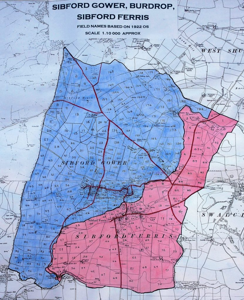
This page lists over 200 names of fields in the Ferris and Gower civil parishes, based on a survey made in 2017-20 by Ivor Hopkyns and Clive Warner. It is by no means definitive; although partly based on historic documents such as land auction notices, it mostly relies on people’s memories of historic names. In addition, field boundaries change over the years; the survey was made against boundaries shown on the 1922 Ordnance Survey map pictured above, but below we use the current OS map.
On the 1922 map, the fields are numbered in separate sequences for Ferris (the red area) and Gower (blue). They are distinguished by the prefix F or G in the map and list of field names below.
Click on a map marker to see the field name. You’ll need to zoom in a bit for the modern field boundaries to become visible as black lines (usually straight); the scale indicator at bottom left should show “300 m” or lower.
Click / touch a field name to find it on the map.
- Above House Field (G46)
- Allotments (G101a)
- Arthurs Bank (F47)
- Asterley Close (F18)
- Back Field (F38)
- Backside Ground (G37)
- Barn Ground (G28a)
- Barn Ground (also Hollow Furze) (G13)
- Barnfield (G43)
- Barnfield (G89)
- Big Bank (G164b)
- Big Heath (G163)
- Big Meadow (F43)
- Blenheim (G174)
- Boscotts Piece (G20a)
- Bottom Field (G179)
- Bowyer (F52)
- Briary Lake (F69)
- Brioney Leys (G127)
- Brons (F73)
- Broom Hill Bank (F59)
- Bunkers Hill (G95)
- Bush Brake Ground (G9)
- Bush Ground (F80)
- Butts Slad (G98)
- Cairns (G180)
- Cairns Well (G182/183)
- Cannings Bank (G128)
- Chillaway Barn (G178)
- Church Furlong (F84)
- Clay Pits (F23)
- Colony (G67/68)
- Colony (G97)
- Combe Leys (G30)
- Cow Lessor (F13)
- Dairy Ground (F34)
- Dairy Ground (G175)
- Dairy Ground (G53)
- Dick Barn Track (G159)
- Dip Field (G166/167)
- Dix Barn (G165)
- Dock Farland (F31)
- Elm Farm (F81)
- Elm Field (F78/79)
- Elm Field (F83)
- Elmridge Dairy Ground (G54)
- Far Combe Leys (G15)
- Far Off Hill Ground (G38)
- Far Over Ground (G1)
- Fermoy (G18)
- Fern Hill (F90/92/93)
- Field Barn Ground (F66/67)
- First Combe Leys (G14)
- First Dairy Ground (G115)
- Folly Field (F65/75/76/77)
- Football (F2)
- Fox Hill (F70)
- Front Field (F39)
- Front Field (G164)
- Fuel Land (G1b)
- Furlong (F36)
- Further Ground (G31)
- Godson Ground (G72)
- Golden Meadow (G87)
- Goodens (F51)
- Great Ground (Blindwell) (F11)
- Great Ground (Egypt) (F9)
- Great Ground (F10)
- Great Ground (F89)
- Great Ground (India) (F8)
- Great Ground (Redland) (F85)
- Greenland (G75)
- Ground above Barn Ground (G27)
- Handywater Farm House (G22)
- Hanging Bank (G52)
- Hanging Ground Bank (G28b)
- Heath (G181)
- Hide Furlong (F29)
- Hill Bottom (F71)
- Hill Ground (F86/87/88)
- Hollow Ground (G8)
- Holly Tree Field (F60)
- Home Farm (F21/22)
- Honey Pit (G39)
- House Field (G47)
- House Ground (F44)
- Hovel Door Ground (G4)
- Know Hill (F50)
- Lady Bell (G96)
- Lane Ground (G42)
- Lime Kiln (F89a/91/94)
- Little Bunkers (G94)
- Little Field (F40)
- Little Field (G132)
- Little Hanging Ground (G29)
- Little Meadow (F45)
- Little Meadow of the Templars (F32a)
- Little Oddies (G35/6)
- Little Stapen Hill (G10)
- Litttle London (F64)
- Long Ground (G12)
- Long Ground (G88)
- Long Heath (G160)
- Long House (F61)
- Long Oak Hill (F68)
- Lower Field (F42)
- Lower Meadow (F48)
- Lower Tom Well (F28)
- Lower Way (G101)
- Mannings Hill (F19/20)
- Meadow (G177)
- Meadow (G44)
- Meadow (G93)
- Mertons (G69/73)
- Mertons (G73)
- Middle Ground (G125)
- Middle Ground (G156)
- Middle Orchard (F16/17)
- Mill Hill (F33)
- Mill Hill (le mylne sydlinge) (F33a)
- Mill Hill Bank (F32)
- Mill Hill Meadow (F30)
- Mill way (F35)
- Mumpford (G78)
- Mushroom Field (G25)
- Mutton (F4)
- New Barn (G76/77)
- Nine Elms (F49)
- Oak Tree (G161)
- Oaktree (G74)
- Oddies (G32)
- Oddies Field (G100)
- One Tree Field (G16/17)
- Orchard (G117)
- Paddock (F53)
- Parsons Barn Field (F12)
- Parsons Barn Field (F14)
- Parsons Barn Field (G173)
- Path Ground (F56/57/58)
- Pit Field (F3)
- Pit Field (G130)
- Pitch Hill (F201)
- Police House and Cell (G145)
- Pool Ground (G126a)
- Poors Allotments (G7)
- Pound (G33/34)
- Pound Lane (G23/24)
- Race Course (G6)
- Ram Hill (G169/170)
- Ram Hill or Five Corners (G152)
- Redlands (G150/151)
- Redlands (G172)
- Rick Yard Ground (G2)
- Road Ground (G124)
- Road Ground (G157/168)
- Road Ground (G55)
- Road Ground (G90)
- Rushymead (G85)
- Ryehill (G71)
- Saltway (G142)
- Sand Fine Ground (G135)
- Sand Pit (G1a)
- Seed Ground (F72)
- Shaws Bank (G91/92)
- Shortlands (F46)
- Shutford Road Field (F5/6)
- Six Acres (G147/148/149)
- Small House (F62)
- Snow Furlong (G136)
- Spring Ground (G155)
- Springfield (G159a)
- Springfield (G177a)
- Springfield (G20/21)
- Springfield (G50/51)
- Stapen Hill (G11)
- Stapenhill (G26)
- Steermans Hedge (G70)
- Stickley (G57/58/59/60)
- Stonepit Ground (G137)
- Taylors Bank (G164a)
- The Barn Field (G139)
- The Barn Ground (G140)
- The Cricket Ground (G120)
- The Cubbs (G123/129)
- The Exchange (F82)
- The Long Field (G131)
- The Orchard (F63)
- The Paddock (F7)
- The Piece (F54/55)
- The Pig and Whistle (G152a)
- The Slinket (G133)
- Three Acre Field (G162)
- Three Ditches (G153/154)
- Tom Well (F27)
- Top Dairy Ground (G141)
- Top Field (F15)
- Top Orchard and Bottom Orchard (G45)
- Top Road Ground (G84)
- Towns End and Stone Pit (F37)
- Triangle (G56)
- Turnpike Over Ground (G5)
- Twelve Acre (G134)
- Tyne Hill (G144)
- Tyne Hill Farmhouse (G146)
- Tysoe Road Ground (G3)
- Upper Ground (F74)
- Upper Ground (G126)
- Vinegar (G143)
- Wash brook (F1)
- Washbrook Ground (G41)
- Water Tower Field (G158)
- Well Head Ground (G40)
- Wellses (G48/49)
- West Town (F24/25)
- West Town (G99)
- Wheathills (G102/103/106)
- Whitemore (G83)
- Whitlands (G171)
- Windmill Green (G138)
- Withycombe (G176)
- Woodford Bottom (F41)